
The decision from Brazil’s environmental authority, Ibama, to prohibit oil exploration in the Foz do Amazonas basin worsened the political crisis in the “Broad Front” coalition of the Luiz Inácio Lula da Silva administration. On one side stands Minister of Environment Marina Silva, Environmental Protection Agency head Rodrigo Agostinho, the Amazon Rainforest, and humanity. On the other are the fossil fuel company Petrobras, Senator Randolfe Rodrigues, Minister of Mines and Energy Alexandre Silveira, many business executives, and those who profit from the ravaging of nature.
In between are social media accounts that regurgitate disinformation about the consequences of oil exploration just 160 kilometers from the coast of Oiapoque, in Amapá.
To help our readers navigate these turbulent waters, SUMAÚMA used its Instagram Stories account to ask what people most want to know about this topic. We invited special reporter Claudia Antunes, who has been investigating this story since February, to put together an informative article based on the messages we received.
Check out the results below. Share this article on social media and in your WhatsApp groups and let’s fight destructive disinformation together.
1. I’ve heard the argument that the well would be very far from the coast, which would greatly reduce risks. Is that true?
Brazil’s oil regulator, the ANP, holds an auction for oil companies, offering what are called blocks. Petrobras has rights to the FZA-M-59 block, which is located 160 kilometers from the coast of Oiapoque, Amapá. The well planned for drilling, which is being called Morpho, is 175 kilometers from the coast and the exploration area is a little over 500 kilometers from the mouth of the Amazon River. That may sound distant, but the area of influence from the river’s sediment covers 300,000 square kilometers. This sediment, which could be affected by any leaks, is what gives the region its special characteristics, with abundant fish stocks, mangroves, and endangered species. That is why the very same ANP calls this area the Foz do Amazonas basin – “mouth of the Amazon River basin.” The risk of an accident in the region and the challenge of containing any oil spills would be bigger than on Brazil’s Southeast coast, for example. This is because the currents on the country’s northern coast are three times stronger and little is known about their dynamics. In 2011, a Petrobras rig attempting to drill a well 110 kilometers from Oiapoque was dragged away, forcing the company to abandon the attempt. The scenarios outlined by Petrobras in the environmental license for the FZA-M-59 block do not include oil reaching the coastline; however, objects have already floated vast distances to Oiapoque, including the wreckage from a rocket launched by neighboring French Guiana in 2014, which had fallen 350 kilometers to the east of the block, even farther from the shore.
This shoreline is made up of mangroves and marshes. The sea moves an entire kilometer inland at high tide. On the other hand, any stain from an oil leak would be expected to reach the territorial waters of French Guiana within ten hours. In March, Petrobras submitted a proposal to Ibama, Brazil’s environmental protection agency, to keep two rescue boats in the Block 59 area, while another four would be docked in Belém, 830 kilometers from the well, a forty-three-minute trip. However, in an April 20 report recommending that the license be denied, the institute’s technical staff felt the accident response time was tight, “at the edge of the limit” found in the Good Practices Handbook for these cases. They argued that at least one of the rescue vessels that would be in Block 59 would have to monitor the movement of any oil slick outside of Brazilian waters, and its replacement would take at least two days to arrive. Moreover, risk would not be limited to the coast.
The Foz do Amazonas basin is a region with an abundance of fish, due to the combination of river sediments with the so-called “great Amazonian reef system,” which lies 200 kilometers off the coast. Marine biodiversity includes endangered species, such as the Guiana dolphin, Amazon river dolphin, sperm whale, fin whale, West Indian manatee, Amazonian manatee, and yellow-spotted river turtle. In relation to atmospheric impacts, scientific studies show this ecosystem works to capture carbon, the main greenhouse gas. Risking this to explore a fuel that is currently the main cause of warming on the planet contradicts efforts to stabilize climate commitments in two ways.
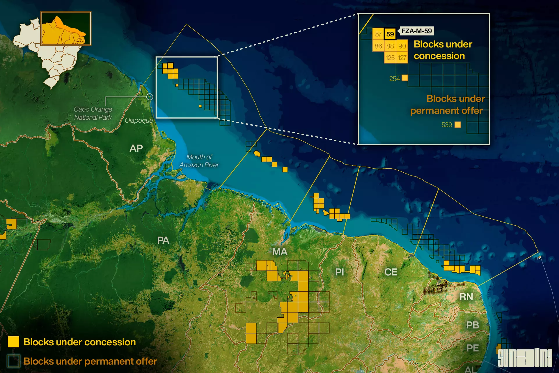 The map shows the position of Petrobras’ block 59. Infographic: Rodolfo Almeida/SUMAÚMA
2. What if Ibama approves drilling? How long will construction take?
The initial drilling stage would take five to six months. This is how long it takes to verify whether there is actually oil in the area of the FZA-M-59 block. After this, if there is oil and a decision is made to explore it, project development would take at least five years. Petrobras has asked Ibama to reconsider its rejection of the license request, saying it would reinforce its emergency plans for cases of oil spills. However, Ibama president Rodrigo Agostinho has no deadline for responding to the request. In early June, the oil concern thus pulled out the rig that was to begin drilling in the block and moved it to the Campos basin area in Southeast Brazil.
However, what is most important is that this is not the only block being licensed in the Foz do Amazonas basin. There are eight other wells with outstanding drilling orders. Considering the entire shoreline of Brazil’s equatorial margin, running from Rio Grande do Norte to Amapá and split into five basins, there are a total of 21 blocks being licensed for oil prospecting. That is why Ibama and the Ministry of Environment and Climate Change are advocating for a broader assessment, to check the cumulative impact that any oil exploration would have throughout the region and to indicate sites where this could be done more securely. This assessment is known as a Sedimentary Area Environmental Study (or AAAS, its acronym in Portuguese), an instrument created through a government directive issued in 2012 and whose execution requires a joint decision with the Ministry of Mines and Energy. According to Marina Silva, an agreement was made to go ahead with the AAAS at a meeting that she and Ibama president Rodrigo Agostinho attended on Tuesday, May 23, with Petrobras CEO Jean Paul Prates, Minister of Mines and Energy Alexandre Silveira, and the President’s Chief of Staff, Rui Costa. The study should take two years.
3. Do other countries share this same deposit and could they explore this oil if Brazil doesn’t?
Not in Brazilian territory. Whatever the company, any search or exploration for oil off the country’s coast must first go through the licensing process with Ibama. As in the case of the FZA-M-59 block,, a license would first be required to see whether there really is any oil in the Foz da Amazonas basin.
As to the deposit, there are indications that the oil reserves in the area are not continuous. Brazil’s three neighboring countries on the northern coastline are French Guiana, Suriname, and Guiana, in order of their proximity to the Foz do Amazonas basin. Intensive oil exploration is taking place in waters off Guiana, a country of 800,000 located next to Venezuela, which holds one of the world’s largest oil reserves. More gas than oil has been found in Suriname’s waters and there has yet to be any large-scale exploration. French Guiana, an overseas territory of France that sits next to Amapá, carried out a series of drilling operations along the coastline that failed to find oil – French company Total suspended operations in 2019. France’s decarbonization plan has banned fossil fuel exploration in national territory starting in 2040.
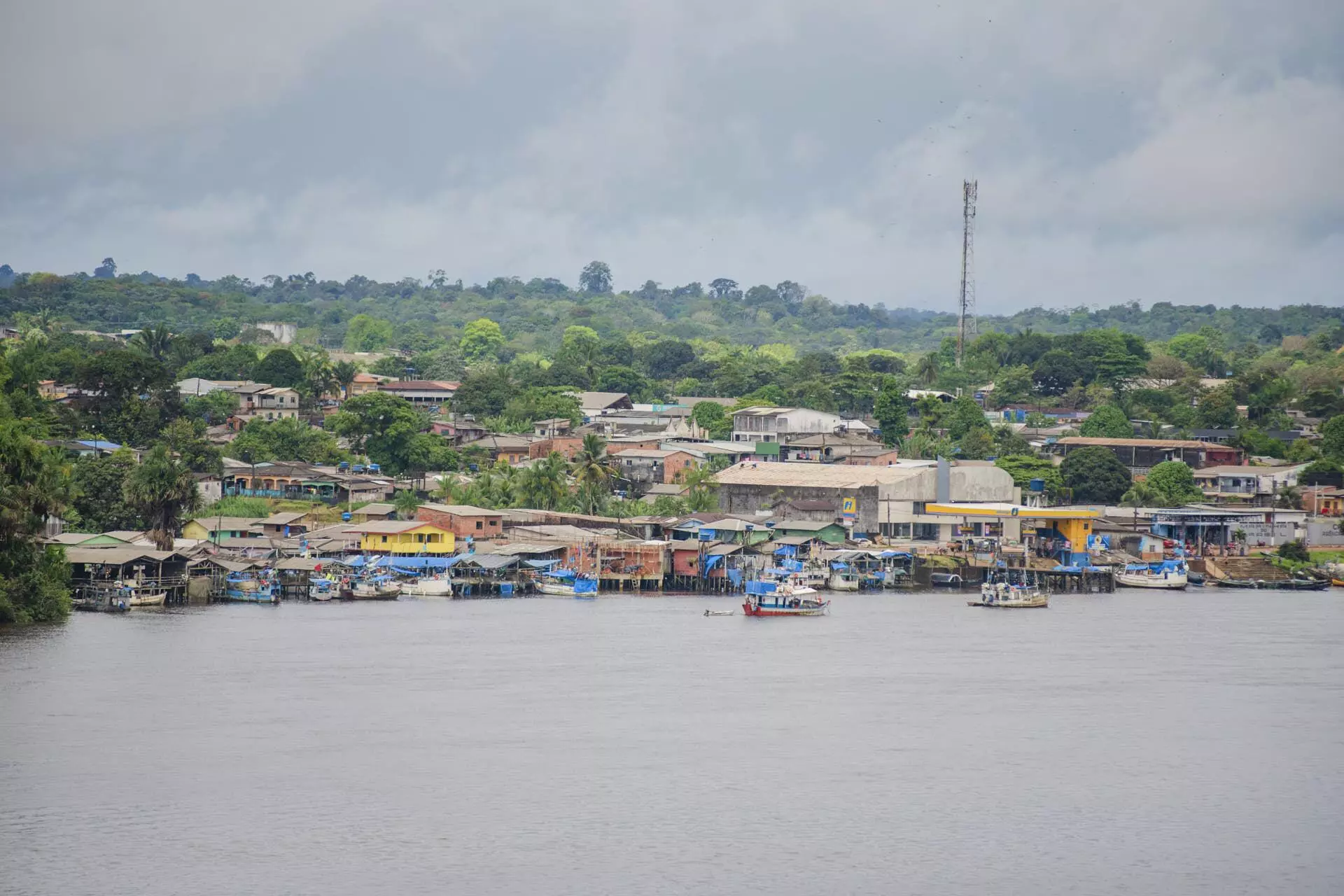
The municipality of Oiapoque, in Amapá state, located 160 kilometers from where oil exploration would take place. Photo: Assembleia Legislativa do Amapá
4. Could oil exploration in Amapá improve living standards for the people there?
Oil exploration would not be likely to bring in any direct jobs, since Petrobras brings in teams from other locations for offshore work. If exploration were to begin, which would happen within at least five years, royalties would be paid to Amapá. However, as with any economic activity, better living standards for the state’s people would depend on how these resources would be distributed and used. In Brazil’s Southeast, where exploration of pre-salt oil is prevalent (in this case, the oil is under a layer of salt, a geological formation different to that found in Brazil’s equatorial margin), royalties did not solve social problems. Oil and gas are also already being explored on land in the Amazon region. However, beyond these immediate considerations, it is estimated that fossil fuel consumption will need to be cut if countries want to keep the planet’s average temperature from rising by more than 1.5 degrees Celsius by the end of this century. Any increase much larger than this would cause extreme climate events and would have catastrophic effects for the Amazonian ecosystem and, consequently, for the people that live there, as well as for the entire planet. That is why there are calls for a plan with a long-term vision, where the Amazon region develops its potential to produce fuels for the future, such as green hydrogen, biomass, and offshore wind power.
5. Is it true that Senator Randolfe Rodrigues voted in favor of oil exploration in the region?
A vote was not held for or against exploration. Ibama’s decision to deny Petrobras a license to drill an exploratory oil well is based on the agency’s technical reports, which analyzed the project submitted by the company and found it to be environmentally unsafe. It is worth noting that this licensing process has been ongoing for nine years. British company BP, which had owned the FZA-M-59 block, walked away, and Petrobras took over the process in late 2021 – without being able to prove its capability to contain the fallout from an accident in the area around the well. Ibama is the agency tasked with approving environmental licensing for every undertaking along the Brazilian coast, and this licensing process does not include hearing from the state’s politicians. What happened was that Senator Randolfe Rodrigues, who intends to run for governor of Amapá in 2026, came out in favor of oil exploration along the state’s coast. Randolfe left the Sustainability Network (Rede Sustentabilidade) party to which Marina Silva, the environment minister, belongs. Nevertheless, the two had already had differences prior to the issue involving the Foz do Amazonas basin.
*This text was updated after publication, with the first response now including a Petrobras proposal to maintain two rescue vessels in the Block 59 area. Nevertheless, the emergency plan in the event of an oil spill was considered insufficient by Ibama.
Translation into Spanish: Meritxell Almarza
English translation: Sarah J. Johnson
Photography editing: Marcelo Aguilar, Mariana Greif and Pablo Albarenga
Page setup: Érica Saboya