
A technical report issued by the Brazilian Institute of the Environment and Renewable Natural Resources (Ibama), recommends denying the request from Petrobras to drill a well in search of oil in the so-called Block 59, in the Foz do Amazonas (Mouth of the Amazon) basin, about 160 km off the coast of the Oiapoque region, in the State of Amapá. SUMAÚMA understands the restricted document, which was filed on April 20, states the venture is unviable from an environmental point of view. It calls for the license to be denied and for the licensing process for prospecting in Block 59, which has been dragging on for nine years, to be dismissed.
The report, signed by Ibama’s entire technical team responsible for the licensing of Block 59, is one of the documents on which Ibama’s president, Rodrigo Agostinho, will base his decision, regarding whether or not to grant Petrobras an operating license. The text mentions shortcomings in the forecasts of the activity’s impacts on the three indigenous lands in the Oiapoque region and the uncertainties in the plan put forward by the state-run company for treatment of fauna, in the case of an accident with an oil spill – in an area where there are endemic endangered species and where the sea currents are particularly strong. It also draws attention to the fact that the venture is bogged down in technical and legal insecurity because a broader assessment has not been made of the compatibility between the oil industry and the region’s entire social and environmental context, using instruments such as the Sedimentary Area Environmental Assessment, which was established in a 2012 decree issued by the ministries of the Environment and Mines and Energy.
The drilling of wells in the Foz do Amazonas (Mouth of the Amazon) basin, where eight other blocks are engaged in the licensing process, has the potential to open a new frontier of oil exploration in Brazil’s equatorial margin, which stretches from the State of Rio Grande do Norte to that of Amapá. The region includes 80% of the country’s mangroves and a reef system that has not been well studied and which is considered to be fundamental for fishing. In addition, knowledge about the dynamics of local marine currents is scarce which makes it hard to predict what would occur in the case of an oil spill and what action should be taken to counter its effects.
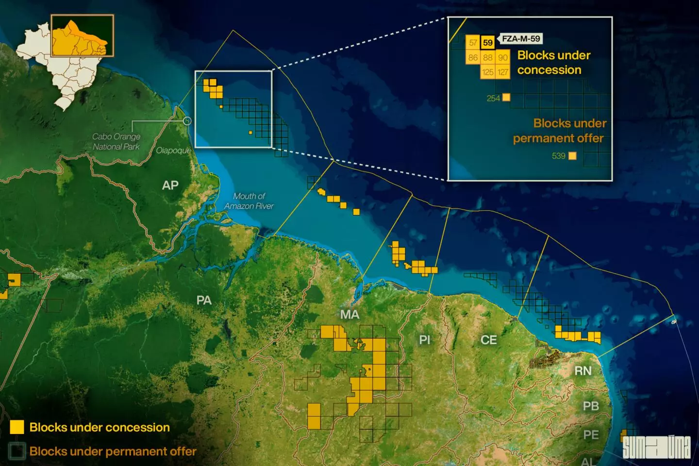
The map shows the position of Petrobras’ block 59. Infographic: Rodolfo Almeida/SUMAÚMA
In total, there are 47 blocks in the equatorial margin that are on “permanent offer” by the National Petroleum Agency (ANP) along with a further 157 that are being studied to be put up for auction. In a letter sent in mid-April to figures of authority in Luiz Inácio Lula da Silva’s government, 80 civil society organizations, including environmental NGOs and associations of indigenous people, fishermen and extractive communities in the Amazon region, called for a Sedimentary Area Environmental Assessment to be carried out prior to any decision being taken in relation to Block 59. They also argued that the opening up of a new frontier of oil exploration is “incoherent” with the need for a “just and inclusive energy transition” and with the “socio-environmental commitments assumed by the Brazilian government.”
The exploration of the equatorial margin was deemed a priority by Petrobras in its strategic plan for the period from 2024 to 2027, which was published in 2022, during the government of the far-right politician Jair Bolsonaro. Appointed during Lula’s government, the company’s present CEO, Jean Paul Prates, has reiterated this priority, stating that the search for oil in the region is essential to maintain the state-run company’s oil and gas business, “even in an energy transition scenario”. More recently, Prates said it is up to “society” to make the decision in relation to exploration in the equatorial margin. In a video he stated: “we are prepared to explore new reserves if society so decides”.
The technical report which was published on the 20th of this month by the Brazilian Institute of the Environment and Renewable Natural Resources (Ibama), points out that Petrobras, at the request of the environmental agency, updated the so-called “modeling” – a computer study that predicts the oil dispersion scenarios in the case of an accident. The so-called Individual Emergency Plan (PEI), which is a fundamental part of the licensing process, is also based on the modeling. Even so, according to the text, the construction of a hydrodynamic base that provides a better representation of the coastal dynamics of the equatorial margin has not yet been concluded, which increases the possibility of errors, taking into account the intensity of the currents and winds in the area of Block 59. To get an idea, the North Brazil Current, the main current in the region, has an average speed of three knots, while that of the Brazil Current, predominant on the southeast coast, is one knot.
The document also observes that Petrobras’ scenarios do not predict oil reaching the coast in the case of a spill, although there are reports of objects reaching the coast of Oiapoque from the high seas, such as stages of a rocket launched in 2014 from the Kourou Space Center in neighboring French Guiana.
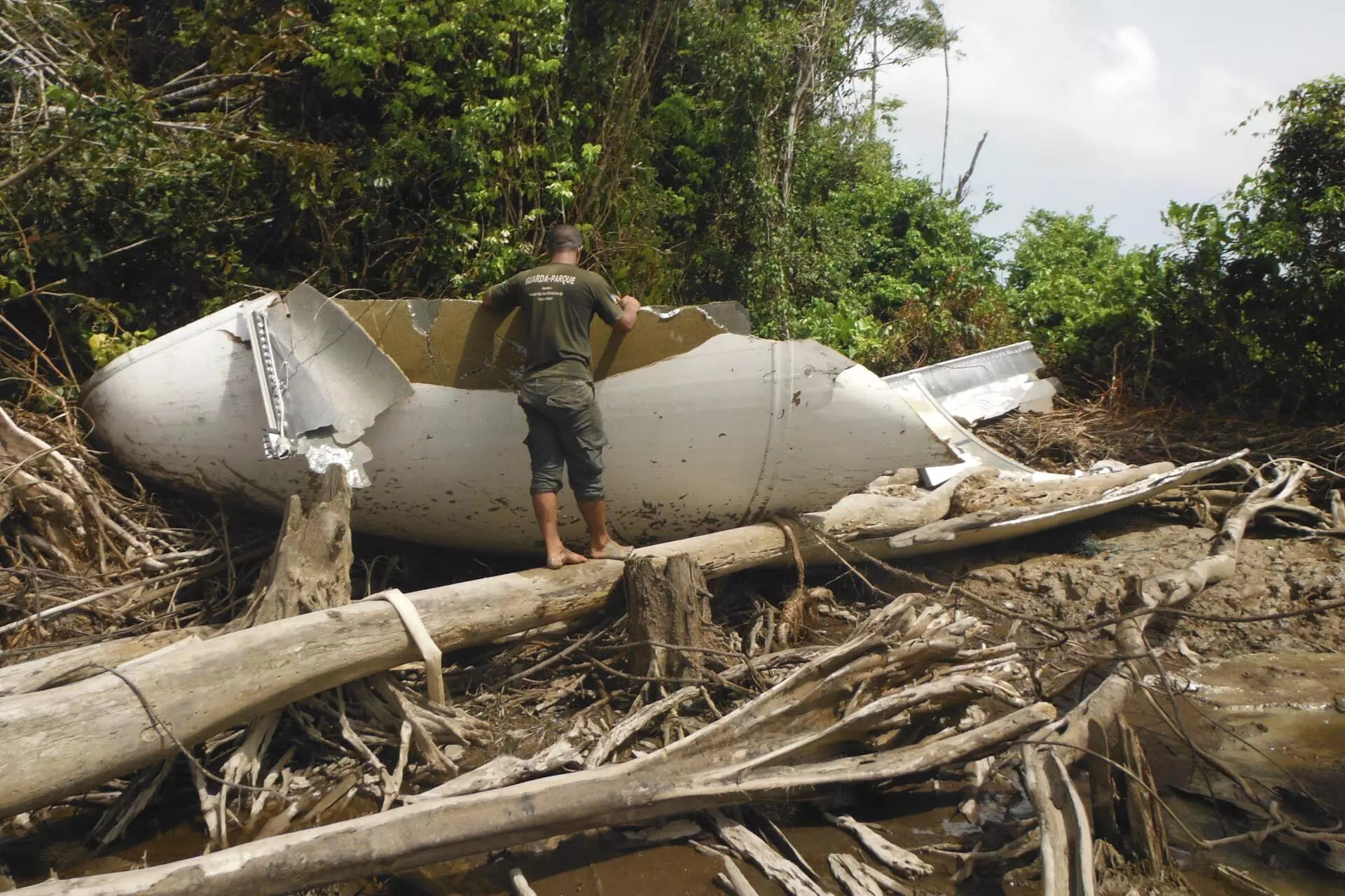
ROCKET REMAINS FOUND IN CABO ORANGE NATIONAL PARK, IN THE OIAPOQUE REGION: A SIGN THE CURRENT CAN CARRY AN OIL SPILL TO BRAZIL. PHOTO: PUBLICITY/ICMBIO
With regard to the impact on indigenous lands, where roughly 8,000 people live, the report mentions that only this February, at a meeting with the Council of Caciques of the Indigenous Peoples of Oiapoque (CCPIO) and other entities, Petrobras acknowledged that the helicopter flights between the city’s airport and the drill ship that it has kept in the area of Block 59 since August last year were already affecting the indigenous peoples, scaring off the wildlife that the villages need for their survival. At the time, the state-owned company pledged to change the altitude of these flights. However, according to the document, an estimated 3,000% increase in air traffic during oil prospecting activity would require a new Environmental Impact Assessment for the specific case of indigenous lands, which Petrobras did not regard as being necessary.
Last but not least, Ibama’s technical report analyzes the Fauna Protection Plan (PPAF) presented by the state-run company as part of the Individual Emergency Plan (PEI). The document rejects Petrobras’ PPAF, and therefore does not recommend the carrying out of the Pre-Operational Assessment, an accident response simulation that is the last stage of the licensing process. According to the text, all of the alternatives proposed by the company for rescuing and transporting animals affected by a possible spill envisage a very long timeframe for this assistance to be provided and do not take into account the possibility of abrupt changes in weather conditions in the area of Block 59, which would affect the time and feasibility of navigation and flights. The report notes that, given the specific characteristics of the coast of the Oiapoque region, which rule out the mooring of large vessels, the entire maritime structure to support Petrobras’ activities would be based in the city of Belém, 830 kilometers from the oil well – a distance that takes boats an average of 43 hours to cover. Even with fast boats, the trip from the capital of the State of Pará to Block 59 would take at least 26 hours.
The report signed by ten specialists was endorsed by the Brazilian Institute of the Environment and Renewable Natural Resources’ (Ibama’s) coordinator of Licensing of Offshore Oil and Gas Exploration (Coexp), Ivan Werneck Sánchez Bassères, and by the general coordinator of Licensing of Marine and Coastal Developments (CGMac), Itagyba Alvarenga Neto. However, according to what SUMAÚMA has established, Ibama’s current interim Licensing Director, Régis Fontana Pinto, partially disagreed with the report – Rodrigo Agostinho, the institute’s president who took over after Lula took office, has not yet appointed the new holder of this position.
In a ruling sent to Agostinho, Fontana Pinto expressed the opinion that the considerations regarding the impacts on indigenous lands and in relation to the prior realization of the Sedimentary Area Environmental Assessment (SAEA) do not represent constraints on the issue of the operating license. Regarding the logistical difficulties for the successful implementation of the Fauna Protection Plan (PPAF), he suggests that Petrobras has a chance to improve the project and demonstrate that it could be viable by carrying out the Pre-Operational Assessment (APO). This accident simulation had been pre-scheduled for March 20, but ended up not taking place on account of the time needed for the analysis, by the Brazilian Institute of the Environment and Renewable Natural Resources (Ibama), of the answers sent by the state-run company in response to its observations regarding the Fauna Protection Plan and the relationship with indigenous peoples.
In his ruling, filed on the 27th, the interim Licensing Director recognizes the weight of a decision that could result in the opening up of a new oil exploration frontier, but says that this assessment is not up to Ibama, but rather to higher authorities that are responsible for deciding the country’s environmental and energy policy.
SUMAÚMA tried to get in touch with the president of Ibama, but up until the publication of this text he had not made any comments regarding his institute’s technical report or Régis Fontana’s opinion.
What Petrobras says
In a statement sent to SUMAÚMA following the publication of this report, Petrobras says it is “waiting for the government to announce its position” regarding the request to check whether or not there is an oil deposit in Block 59, and stresses that the oil well itself is “located 175 kilometers from the coast of the State of Amapá and more than 500 kilometers” from the mouth of the Amazon River.
“The company has been diligently carrying out its environmental licensing process, complying with all the requirements established by the environmental agencies, and reinforces that it will abide by any whatsoever ruling, whether it is the go-ahead for drilling or if it is decided to opt for further studies in order to assess the feasibility of implementing a drilling campaign in the basin,” declared the state-run company.
The company also says that only after the well has been drilled will it confirm the asset’s potential, the existence and profile of the prospective deposit. “We have complied with all the requirements and are waiting for the government’s decision. We do not want to be rushed and, contrary to some news reports in the press, there is no pressure of any whatsoever kind from Petrobras. We are ready from a technical point of view and are just waiting for the official position in relation to our drilling campaign in the region,” stated Petrobras’ CEO, Jean Paul Prates, according to the statement.
The company pointed out that each basin in the equatorial margin has different characteristics. “The company’s assessment is that the equatorial margin is the new frontier for a major energy plan for Brazil, involving exploration and production activities and offshore wind resources,” says the text. “Petrobras’ values include a respect for life, people and the environment and it will continue to conduct all of its operations in strict accordance with the operational safety rules and best practices in relation to social and environmental responsibility,” it concludes.
Translated by Mark Murray